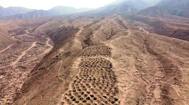
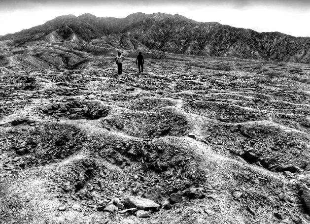
The Band of Holes is a geological wonder that is also known as Monte Sierpe or Cerro Viruela (smallpox hill). When you look down from above, the mile-long strip of land with the strange marks might seem like tire tracks left by an ancient monster dirt bike, but you would be mistaken. A series of about 5,000–6,000 holes that are about the size of a man were found in the Pisco Valley of Peru’s Nazca Plateau.
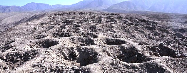
The hole diameter is about 1 meter, with a depth between 50 and 100 cm. Their width varies from 14 to 21 meters, with an average of 19 meters, arranged in discernible blocks or segments. A band of holes extends over uneven terrain in a generally north-south direction. It runs for about 1.5 kilometers uphill from the valley’s edge. The holes may have been dug to measure the produce farmers had to deliver as a tribute to the Inca kings, according to Charles Stanish, a specialist in Andean cultures.

Even though band holes are unknown to locals, nor do they know how they were used, Various theories have been presented over the decades, including grave theories, defensive positions, and storage areas. It is also believed that in the Inca Empire (1438–1533), the pits were thought to have served as storage pits.
In some instances, artificial mounds were dug into the ground; in others, small rock structures were erected on the surface. They called these groups of holes blocks, and each block has a different pattern of holes. According to Stanish, Inca states were far-flung empires with some autonomy among their separate regions.
Pisco Valley administrators may have devised the Band of Holes as a local solution to the problem of measuring tribute. In addition to Machu Picchu, Stanish notes that local influences become more evident as you move farther from the Inca centers. A local need may have been fulfilled by Monte Sierpe.” Archeologists from the University of California mapped the Band of Holes using a drone in 2015, estimating that the site contains between five to six thousand depressions.

While archeologists did not find any direct evidence, there were several colcas (Inca-period storage houses) nearby, as well as Inca-period pottery found near the band. This evidence indicates that the Band of Holes was built around the 15th century, after the Inca Empire conquered the Chincha people. Furthermore, they felt that the holes may have been used to store something in the past, but they weren’t certain what or why.
The aviator Robert Shippee published an aerial photograph in National Geographic in the 1930s; that resulted in the site being first brought to the public’s attention. The band holes have not been visited by archeologists since then. During a 1953 survey of the area, American explorer Victor Wolfgang von Hagen described the pits as “graves,” but they were empty. About 5,000 to 6,000 graves of this type are estimated to exist in the area, according to him.

Archaeologist John Hyslop published a book in 1984, that suggested that the circular structures may have served as storage pits, similar to the ones found on the Peruvian south coast in Quebrada de la Vaca and Tambo Colorado.
There are four miles between the Band of Holes and Tambo Colorado, a massive fifteenth-century Inca administrative center that overlooks the agriculturally productive Pisco Valley. There is a road connecting the valley with Tambo Colorado that leads to the Band of Holes. Stanish recommends stopping here, measuring your produce, and ensuring you have the correct amount of tribute.
The blocks of holes might have belonged to different extended families, or ayllu, which would have made up separate tax-paying groups. In front of the state’s accountants, who could have kept a tally with khipus, each social group may have filled up their block with squash, maize, or any other produce. Tambo Colorado could also have been used as storage for the goods.
What is the reason that no parallel to the Band of Holes exists anywhere else on the site if it was used by the Inca Empire to measure tribute? Protzen disagrees, according to Jean-Pierre Protzen of the University of California Los Angeles, a specialist in Inca architecture.
Having worked at Tambo Colorado for years, Protzen believes the Band of Holes is not contemporaneous with the massive Inca center. Protzen claims that Monte Sierpe (serpent mountain) may have been associated with other, earlier major sites near it. Possibly, guano, an imperative fertilizer, was stored in the holes. Therefore, it is still unclear who or what caused the band holes.
Read More: The Tromelin Island Slaves


